ginga Posted September 12, 2018 Share Posted September 12, 2018 6 minutes ago, graygo said: Definitely not Danderhall and pretty certain it's not Gilmerton either. Might be Calder Road before the bypass was built, at the time they made the new dual carriageway - looks like the old police station at the back. Quote Link to comment Share on other sites More sharing options...
been here before Posted September 12, 2018 Share Posted September 12, 2018 Quote Link to comment Share on other sites More sharing options...
All roads lead to Gorgie Posted September 12, 2018 Share Posted September 12, 2018 13 minutes ago, graygo said: Definitely not Danderhall and pretty certain it's not Gilmerton either. I still can't place that. Obviously at the city limits somewhere. Quote Link to comment Share on other sites More sharing options...
Maroon Sailor Posted September 12, 2018 Author Share Posted September 12, 2018 Quote Link to comment Share on other sites More sharing options...
Maroon Sailor Posted September 12, 2018 Author Share Posted September 12, 2018 Quote Link to comment Share on other sites More sharing options...
Maroon Sailor Posted September 12, 2018 Author Share Posted September 12, 2018 Quote Link to comment Share on other sites More sharing options...
graygo Posted September 12, 2018 Share Posted September 12, 2018 6 minutes ago, Maroon Sailor said: East Craigs? Quote Link to comment Share on other sites More sharing options...
All roads lead to Gorgie Posted September 12, 2018 Share Posted September 12, 2018 6 minutes ago, graygo said: East Craigs? Think so. I used to shop there when it was a Safeway and that goes back a bit. Quote Link to comment Share on other sites More sharing options...
graygo Posted September 12, 2018 Share Posted September 12, 2018 4 minutes ago, All roads lead to Gorgie said: Think so. I used to shop there when it was a Safeway and that goes back a bit. Me too, there was a paper paper shop (Menzies?) a hairdresser and a bookies if I mind right, back in about 1988. Quote Link to comment Share on other sites More sharing options...
Radio Ga Ga Posted September 12, 2018 Share Posted September 12, 2018 14 minutes ago, graygo said: East Craigs? Definitely the old Safeway, I can remember it being built and the Radio Forth Road Show at the formal opening, FFS I’m getting old! Quote Link to comment Share on other sites More sharing options...
Radio Ga Ga Posted September 12, 2018 Share Posted September 12, 2018 2 minutes ago, graygo said: Me too, there was a paper paper shop (Menzies?) a hairdresser and a bookies if I mind right, back in about 1988. Correct Quote Link to comment Share on other sites More sharing options...
All roads lead to Gorgie Posted September 12, 2018 Share Posted September 12, 2018 7 minutes ago, graygo said: Me too, there was a paper paper shop (Menzies?) a hairdresser and a bookies if I mind right, back in about 1988. There was a pub on the roundabout, I think it is called the Mid Yoken or something similar now. The 31 bus started from a stop near there too. Quote Link to comment Share on other sites More sharing options...
graygo Posted September 12, 2018 Share Posted September 12, 2018 2 minutes ago, All roads lead to Gorgie said: There was a pub on the roundabout, I think it is called the Mid Yoken or something similar now. The 31 bus started from a stop near there too. Had a wee drink in there on the morning of my wedding. Quote Link to comment Share on other sites More sharing options...
All roads lead to Gorgie Posted September 12, 2018 Share Posted September 12, 2018 1 minute ago, graygo said: Had a wee drink in there on the morning of my wedding. Must have been a real locals pub as it is hidden away, unless you were shopping at safeways that is. Quote Link to comment Share on other sites More sharing options...
graygo Posted September 12, 2018 Share Posted September 12, 2018 14 minutes ago, All roads lead to Gorgie said: Must have been a real locals pub as it is hidden away, unless you were shopping at safeways that is. I lived in Fauldburn just down the road at the time, that pub was like the wild west at the weekend. Quote Link to comment Share on other sites More sharing options...
John mcCartney Posted September 12, 2018 Share Posted September 12, 2018 although ive put this on here,would like to know exactly whare barney`s gaff was and when it went Quote Link to comment Share on other sites More sharing options...
Tazio Posted September 12, 2018 Share Posted September 12, 2018 Newhaven opposite the harbour. The story always went that the cellar filled with water when the tide was in. Quote Link to comment Share on other sites More sharing options...
All roads lead to Gorgie Posted September 12, 2018 Share Posted September 12, 2018 10 minutes ago, John mcCartney said: although ive put this on here,would like to know exactly whare barney`s gaff was and when it went Barney Battles Jr died in 1979 aged 74 so possible a bit before then. Just says he owned a pub in Newhaven. Quote Link to comment Share on other sites More sharing options...
superjack Posted September 13, 2018 Share Posted September 13, 2018 19 hours ago, Lemongrab said: I wonder how much they charged back then. It's £2.50 n hour now. I'm sure that's Hailesland Place. I think other areas had venchies too. That's the baby, I used to love playing there. Iirc, 1 got built next to where I lived, across from dumbryden grove, where they built the police station a few years later. Quote Link to comment Share on other sites More sharing options...
John mcCartney Posted September 13, 2018 Share Posted September 13, 2018 10 hours ago, Tazio said: Newhaven opposite the harbour. The story always went that the cellar filled with water when the tide was in. just had a look on google map street view,building is still there and is residential....in between the harbour inn on fishmarket square and the old cafe now a restaurant,the lighthouse.....great stuff Quote Link to comment Share on other sites More sharing options...
systemx Posted September 13, 2018 Share Posted September 13, 2018 23 hours ago, ginga said: Might be Calder Road before the bypass was built, at the time they made the new dual carriageway - looks like the old police station at the back. Think your correct.My wife lived in the flats being built to the left.The road was like this until first flats built then it was dualled Quote Link to comment Share on other sites More sharing options...
Maroon Sailor Posted September 13, 2018 Author Share Posted September 13, 2018 23 hours ago, ginga said: Might be Calder Road before the bypass was built, at the time they made the new dual carriageway - looks like the old police station at the back. If that is Calder Road is that looking East or West ? Still having trouble picturing it now Quote Link to comment Share on other sites More sharing options...
Maroon Sailor Posted September 13, 2018 Author Share Posted September 13, 2018 Quote Link to comment Share on other sites More sharing options...
Maroon Sailor Posted September 13, 2018 Author Share Posted September 13, 2018 Quote Link to comment Share on other sites More sharing options...
Maroon Sailor Posted September 13, 2018 Author Share Posted September 13, 2018 Quote Link to comment Share on other sites More sharing options...
Maroon Sailor Posted September 13, 2018 Author Share Posted September 13, 2018 Quote Link to comment Share on other sites More sharing options...
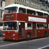
All roads lead to Gorgie Posted September 13, 2018 Share Posted September 13, 2018 29 minutes ago, Maroon Sailor said: If that is Calder Road is that looking East or West ? Still having trouble picturing it now Here's the dual carriageway being built in 1971. Quote Link to comment Share on other sites More sharing options...
Janbo1874 Posted September 13, 2018 Share Posted September 13, 2018 19 minutes ago, Maroon Sailor said: The arse end of Holyrood road forget the name of the brewery. Quote Link to comment Share on other sites More sharing options...
Janbo1874 Posted September 13, 2018 Share Posted September 13, 2018 20 minutes ago, Maroon Sailor said: Whitehouse Loan the old Bruntsfield womans hospital. Quote Link to comment Share on other sites More sharing options...
All roads lead to Gorgie Posted September 13, 2018 Share Posted September 13, 2018 (edited) 13 minutes ago, Janbo1874 said: The arse end of Holyrood road forget the name of the brewery. Is that not King's stables Rd ? Edited September 13, 2018 by All roads lead to Gorgie Quote Link to comment Share on other sites More sharing options...
graygo Posted September 13, 2018 Share Posted September 13, 2018 41 minutes ago, Janbo1874 said: The arse end of Holyrood road forget the name of the brewery. Scottish and Newcastle Quote Link to comment Share on other sites More sharing options...
Radio Ga Ga Posted September 13, 2018 Share Posted September 13, 2018 1 hour ago, Maroon Sailor said: If that is Calder Road is that looking East or West ? Still having trouble picturing it now Think that is the Calders being constructed on the LHS of the picture, the building at the bus terminus ( drivers toilet I think) is still there on Google Earth Quote Link to comment Share on other sites More sharing options...
All roads lead to Gorgie Posted September 13, 2018 Share Posted September 13, 2018 6 minutes ago, graygo said: Scottish and Newcastle I have google mapped the earlier image and it is King's Stables Rd where it turns towards the Grassmarket and not Holyrood Rd. You can see the building with the green covering! Quote Link to comment Share on other sites More sharing options...
graygo Posted September 13, 2018 Share Posted September 13, 2018 Just now, All roads lead to Gorgie said: I have google mapped the earlier image and it is King's Stables Rd where it turns towards the Grassmarket and not Holyrood Rd. You can see the building with the green covering! Fair play, I was more answering the question about the name of the brewery at Holyrood Road. Quote Link to comment Share on other sites More sharing options...
All roads lead to Gorgie Posted September 13, 2018 Share Posted September 13, 2018 1 minute ago, graygo said: Fair play, I was more answering the question about the name of the brewery at Holyrood Road. No worries, I should have quoted janbo again rather than your fine self. It was the bend in the road that gave it away but I can see how it could look like the former brewery site so janbo wasn't far off. Quote Link to comment Share on other sites More sharing options...
Maroon Sailor Posted September 13, 2018 Author Share Posted September 13, 2018 (edited) 15 minutes ago, Radio Ga Ga said: Think that is the Calders being constructed on the LHS of the picture, the building at the bus terminus ( drivers toilet I think) is still there on Google Earth That's where I thought it might be. The old Sighthill terminus for the 34 and 35. Never knew there was a police station up there though Edited September 13, 2018 by Maroon Sailor Quote Link to comment Share on other sites More sharing options...
All roads lead to Gorgie Posted September 13, 2018 Share Posted September 13, 2018 Back to the ancient again. Quote Link to comment Share on other sites More sharing options...
graygo Posted September 13, 2018 Share Posted September 13, 2018 2 minutes ago, All roads lead to Gorgie said: Back to the ancient again. Granton Square? Quote Link to comment Share on other sites More sharing options...
All roads lead to Gorgie Posted September 13, 2018 Share Posted September 13, 2018 4 minutes ago, graygo said: Granton Square? Spot on. Here's another Quote Link to comment Share on other sites More sharing options...
Maroon Sailor Posted September 13, 2018 Author Share Posted September 13, 2018 Quote Link to comment Share on other sites More sharing options...
Maroon Sailor Posted September 13, 2018 Author Share Posted September 13, 2018 Quote Link to comment Share on other sites More sharing options...
ginga Posted September 13, 2018 Share Posted September 13, 2018 2 hours ago, Maroon Sailor said: If that is Calder Road is that looking East or West ? Still having trouble picturing it now Small building next to the bus is the drivers toilet at what was the terminus (looking West towards Hermiston) Quote Link to comment Share on other sites More sharing options...
ginga Posted September 13, 2018 Share Posted September 13, 2018 1 hour ago, Radio Ga Ga said: Think that is the Calders being constructed on the LHS of the picture, the building at the bus terminus ( drivers toilet I think) is still there on Google Earth Thanks for the picture - think this shows I am correct. Quote Link to comment Share on other sites More sharing options...
ginga Posted September 13, 2018 Share Posted September 13, 2018 (edited) 1 hour ago, Maroon Sailor said: That's where I thought it might be. The old Sighthill terminus for the 34 and 35. Never knew there was a police station up there though Police house / station right next to the canal bridge - sure it burnt down in the 1960's Edited September 13, 2018 by ginga More info Quote Link to comment Share on other sites More sharing options...
luckyBatistuta Posted September 14, 2018 Share Posted September 14, 2018 2 hours ago, All roads lead to Gorgie said: Spot on. Here's another ‘West Harbour Road looking towards Granton square and Lower Granton Road? Quote Link to comment Share on other sites More sharing options...
Tazio Posted September 14, 2018 Share Posted September 14, 2018 2 minutes ago, luckyBatistuta said: ‘West Harbour Road looking towards Granton square and Lower Granton Road? Yep, painful memories of my bike wheel getting stuck in those tracks when I was a kid. Quote Link to comment Share on other sites More sharing options...
Maroon Sailor Posted September 14, 2018 Author Share Posted September 14, 2018 Quote Link to comment Share on other sites More sharing options...
Maroon Sailor Posted September 14, 2018 Author Share Posted September 14, 2018 Quote Link to comment Share on other sites More sharing options...
Maroon Sailor Posted September 14, 2018 Author Share Posted September 14, 2018 Quote Link to comment Share on other sites More sharing options...
Maroon Sailor Posted September 14, 2018 Author Share Posted September 14, 2018 Quote Link to comment Share on other sites More sharing options...

Recommended Posts
Join the conversation
You can post now and register later. If you have an account, sign in now to post with your account.