NANOJAMBO Posted August 4, 2018 Share Posted August 4, 2018 1 hour ago, Montgomery Brewster said: This is a picture from the 70’s. The top part of the lights are definitely new. hard to tell if it’s the original bases though. I reckon these are original posts - if you look in middle foreground (to left of bus) you can see the new type - one piece concrete with a curved top. They also look taller. At around that time lamp posts were being replaced but also repositioned away from the kerb edge due to the number of road deaths involving cars hitting lamp posts. Quote Link to comment Share on other sites More sharing options...
Montgomery Brewster Posted August 4, 2018 Share Posted August 4, 2018 4 hours ago, NANOJAMBO said: I reckon these are original posts - if you look in middle foreground (to left of bus) you can see the new type - one piece concrete with a curved top. They also look taller. At around that time lamp posts were being replaced but also repositioned away from the kerb edge due to the number of road deaths involving cars hitting lamp posts. If you look at the two pics the top bit is slightly different. The bump at the top is shorter than the old ones. a good reproduction all the same Quote Link to comment Share on other sites More sharing options...
Maroon Sailor Posted August 7, 2018 Author Share Posted August 7, 2018 (edited) My old school near the top of this picture. Not there anymore Edited August 7, 2018 by Maroon Sailor Quote Link to comment Share on other sites More sharing options...
Maroon Sailor Posted August 7, 2018 Author Share Posted August 7, 2018 Quote Link to comment Share on other sites More sharing options...
SUTOL Posted August 7, 2018 Share Posted August 7, 2018 51 minutes ago, Maroon Sailor said: Looks like Mardale Crescent, in Merchiston. https://goo.gl/maps/Meu2x2NJR3L2 Quote Link to comment Share on other sites More sharing options...
¼½¾ Posted August 7, 2018 Share Posted August 7, 2018 2 hours ago, Maroon Sailor said: My old school near the top of this picture. Not there anymore Dumbryden? I can see my old hoose. Quote Link to comment Share on other sites More sharing options...
Maroon Sailor Posted August 7, 2018 Author Share Posted August 7, 2018 22 minutes ago, Lemongrab said: Dumbryden? I can see my old hoose. My old hoose is out of shot but I'm glad it's still there. When was that dual carriageway built on the Calder Road ? Those buses were still in service early 70's but I've always known the dual carriageway to be there. Not much else has changed from that phot - apart from Dumbryden School and the trees that have replaced the grass bank going up Hailesland Road past the school. Quote Link to comment Share on other sites More sharing options...
Maroon Sailor Posted August 7, 2018 Author Share Posted August 7, 2018 1 hour ago, SUTOL said: Looks like Mardale Crescent, in Merchiston. https://goo.gl/maps/Meu2x2NJR3L2 Not much change to that Street Quote Link to comment Share on other sites More sharing options...
Maroon Sailor Posted August 7, 2018 Author Share Posted August 7, 2018 Quote Link to comment Share on other sites More sharing options...
¼½¾ Posted August 7, 2018 Share Posted August 7, 2018 2 minutes ago, Maroon Sailor said: My old hoose is out of shot but I'm glad it's still there. When was that dual carriageway built on the Calder Road ? Those buses were still in service early 70's but I've always known the dual carriageway to be there. Not much else has changed from that phot - apart from Dumbryden School and the trees that have replaced the grass bank going up Hailesland Road past the school. I think the dual carriage was made in 1972. Well before I moved up this way, so it's all I've known too. Quote Link to comment Share on other sites More sharing options...
Maroon Sailor Posted August 7, 2018 Author Share Posted August 7, 2018 17 minutes ago, Lemongrab said: I think the dual carriage was made in 1972. Well before I moved up this way, so it's all I've known too. 72 is when I started at Dumbryden. 1972-79 and I enjoyed being at that school. Hated secondary school right enough ! Couldn't get out of that quick enough ! Quote Link to comment Share on other sites More sharing options...
stuartmitchell Posted August 7, 2018 Share Posted August 7, 2018 On 24/06/2018 at 22:14, Maroon Sailor said: Apparently there was Easter Road Halt as well Two different stops. One at Abbeyhill and One at Easter Road. The line from Abbeyhill merged with a line that used to go waste processing plant at the bottom of McDonald Rd off Broughton St. If you google map sunnyside you'll see the line of the old railway merging behind the hibs supporters club. Love this stuff! If you google Glasgow abandoned low level they have a thread like this but it's now over 70 pages. Quote Link to comment Share on other sites More sharing options...
stuartmitchell Posted August 7, 2018 Share Posted August 7, 2018 On 25/06/2018 at 17:01, frankblack said: Not sure specifically about Leith North. However, Leith Citadel is still very visible on Commercial Street - it is a youth club but you can still see the platforms: https://www.google.co.uk/maps/@55.9775014,-3.1764355,3a,75y,130.54h,85.3t/data=!3m6!1e1!3m4!1sd3GQrmbqMXwt6tVah4f9Mg!2e0!7i13312!8i6656 Edit - I didn't see your reply when I posted this. I work in the area and the Citadel (or arch that remains of it) has a very interesting history with Oliver Cromwell. History of Leith Citadel Leith North Lies at North Ft Street just by the Dreadnought pub. The road has been re-aligned over the years but the line as you may expect ran right into the docks. You used to be able to see the lines near the cruise terminal. Not sure if the trams work ruined that or not. Quote Link to comment Share on other sites More sharing options...
Gimme an H... Posted August 7, 2018 Share Posted August 7, 2018 (edited) On 7/2/2018 at 23:30, luckyBatistuta said: Bristo Street, a bustling area lost to the University, even though the local residents fought hard against the proposals (still happening to this day) See that Parkers shop...where is that exactly now? Is that Bristo Square where the Underbelly is now? In laws have a painting of it at their house and no one was sure where it was! https://goo.gl/maps/9LC1Kiv66eP2 I've got it at this junction? Edited August 7, 2018 by Gimme an H... Quote Link to comment Share on other sites More sharing options...
SUTOL Posted August 7, 2018 Share Posted August 7, 2018 18 minutes ago, Gimme an H... said: See that Parkers shop...where is that exactly now? Is that Bristo Square where the Underbelly is now? In laws have a painting of it at their house and no one was sure where it was! https://goo.gl/maps/9LC1Kiv66eP2 I've got it at this junction? Close but not quite. This old map shows it as I think the triangle of buildings in the middle. That shop being at the point between Charles St and Bristo Str. If you were here enough years ago you would be close to the entrance of he shop. https://goo.gl/maps/zC2hNXgzWNS2 Quote Link to comment Share on other sites More sharing options...
Gimme an H... Posted August 7, 2018 Share Posted August 7, 2018 3 minutes ago, SUTOL said: Close but not quite. This old map shows it as I think the triangle of buildings in the middle. That shop being at the point between Charles St and Bristo Str. If you were here enough years ago you would be close to the entrance of he shop. https://goo.gl/maps/zC2hNXgzWNS2 I was down that wee side path/road earlier on Google. Thought it was around there! Cheers! Quote Link to comment Share on other sites More sharing options...
The Real Maroonblood Posted August 7, 2018 Share Posted August 7, 2018 2 hours ago, Lemongrab said: I think the dual carriage was made in 1972. Well before I moved up this way, so it's all I've known too. I don't think you are far of the mark with the year. Quote Link to comment Share on other sites More sharing options...
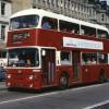
¼½¾ Posted August 7, 2018 Share Posted August 7, 2018 1 hour ago, SUTOL said: Close but not quite. This old map shows it as I think the triangle of buildings in the middle. That shop being at the point between Charles St and Bristo Str. If you were here enough years ago you would be close to the entrance of he shop. https://goo.gl/maps/zC2hNXgzWNS2 Thanks for that. Someone I know has this on their wall and I've never been able to get my head round where the shop was. Their crap explanations haven't helped. So that bus is coming out of Marshall Street? Please tell me I'm right. I've been wondering, on and off, for about two years. Quote Link to comment Share on other sites More sharing options...
SUTOL Posted August 7, 2018 Share Posted August 7, 2018 8 minutes ago, Lemongrab said: Thanks for that. Someone I know has this on their wall and I've never been able to get my head round where the shop was. Their crap explanations haven't helped. So that bus is coming out of Marshall Street? Please tell me I'm right. I've been wondering, on and off, for about two years. I'd say, yes the bus is coming out of Marshall Street. Going by the information I have taken from the old map(s). Maybe an older contributor could recall and confirm... Quote Link to comment Share on other sites More sharing options...
The Real Maroonblood Posted August 7, 2018 Share Posted August 7, 2018 5 minutes ago, SUTOL said: I'd say, yes the bus is coming out of Marshall Street. Going by the information I have taken from the old map(s). Maybe an older contributor could recall and confirm... Yes it is Quote Link to comment Share on other sites More sharing options...
Sharpie Posted August 7, 2018 Share Posted August 7, 2018 1 hour ago, Lemongrab said: Thanks for that. Someone I know has this on their wall and I've never been able to get my head round where the shop was. Their crap explanations haven't helped. So that bus is coming out of Marshall Street? Please tell me I'm right. I've been wondering, on and off, for about two years. It sure is , it would probably be a #2 heading for Broomhouse, for the life of me although I rode that bus all the time I am not sure where it went, from that location. At my age the memory is the second thing to go, I can't remember the first thing but I am sure it had something to do with the wife. Quote Link to comment Share on other sites More sharing options...
Montgomery Brewster Posted August 7, 2018 Share Posted August 7, 2018 1 hour ago, SUTOL said: I'd say, yes the bus is coming out of Marshall Street. Going by the information I have taken from the old map(s). Maybe an older contributor could recall and confirm... See this for more info. The bus isn’t coming out of the bit of Marshall street that is left now. Marshall street continued on and joined onto Bristo street before it was all demolished. See this map for a better explanation . https://maps.nls.uk/view/142842464 There’s a good pic on this thread somewhere that shows you better were Parker’s was. If you are passing these days it would have been about the middle of what’s left of the square bounded by the uni and mcewan hall. So so if your standing at the junction where the 23 and 27 head right and the 41 , 42 buses turns left coming from the city . Parker’s was kind of diagonal towards were chapel street is now. Quote Link to comment Share on other sites More sharing options...
Montgomery Brewster Posted August 7, 2018 Share Posted August 7, 2018 4 hours ago, Gimme an H... said: See that Parkers shop...where is that exactly now? Is that Bristo Square where the Underbelly is now? In laws have a painting of it at their house and no one was sure where it was! https://goo.gl/maps/9LC1Kiv66eP2 I've got it at this junction? Doesn’t help that every picture that ever seemed to have been taken shows they same view. A view pointing towards mcewan hall would have been good - i’ll Just go back 50 years and take one lol Quote Link to comment Share on other sites More sharing options...
¼½¾ Posted August 7, 2018 Share Posted August 7, 2018 Thanks guys. I thought I had it sussed, then it was taken away, but I think I've got it now. Using a tool on the NLS site I was able to compare and old and newish map and pinpoint where the tip of 'the triangle' was. That bloody university hasn't half ruined the area. Quote Link to comment Share on other sites More sharing options...
Maroon Sailor Posted August 7, 2018 Author Share Posted August 7, 2018 Anybody recognise this ? Quote Link to comment Share on other sites More sharing options...
Maroon Sailor Posted August 7, 2018 Author Share Posted August 7, 2018 Quote Link to comment Share on other sites More sharing options...
Maroon Sailor Posted August 7, 2018 Author Share Posted August 7, 2018 Quote Link to comment Share on other sites More sharing options...
Montgomery Brewster Posted August 7, 2018 Share Posted August 7, 2018 53 minutes ago, Lemongrab said: Thanks guys. I thought I had it sussed, then it was taken away, but I think I've got it now. Using a tool on the NLS site I was able to compare and old and newish map and pinpoint where the tip of 'the triangle' was. That bloody university hasn't half ruined the area. Good work Quote Link to comment Share on other sites More sharing options...
Janbo1874 Posted August 7, 2018 Share Posted August 7, 2018 2 hours ago, Maroon Sailor said: Anybody recognise this ? Cramond Road South Quote Link to comment Share on other sites More sharing options...
been here before Posted August 7, 2018 Share Posted August 7, 2018 2 hours ago, Maroon Sailor said: Anybody recognise this ? Its a Liddells Laundry van. Too easy man. Quote Link to comment Share on other sites More sharing options...
SUTOL Posted August 7, 2018 Share Posted August 7, 2018 11 minutes ago, Janbo1874 said: Cramond Road South Yep, though it looked familiar, just the houses have been whitewashed. https://goo.gl/maps/QEDCix8bLBN2 Quote Link to comment Share on other sites More sharing options...
luckyBatistuta Posted August 7, 2018 Share Posted August 7, 2018 3 hours ago, Maroon Sailor said: Anybody recognise this ? 56 minutes ago, Janbo1874 said: Cramond Road South 43 minutes ago, SUTOL said: Yep, though it looked familiar, just the houses have been whitewashed. https://goo.gl/maps/QEDCix8bLBN2 Barnton Gardens Quote Link to comment Share on other sites More sharing options...
SUTOL Posted August 7, 2018 Share Posted August 7, 2018 8 minutes ago, luckyBatistuta said: Barnton Gardens Zoom in on the road name sign in the Streetview image I've linked to. Quote Link to comment Share on other sites More sharing options...
Maroon Sailor Posted August 7, 2018 Author Share Posted August 7, 2018 1 hour ago, Janbo1874 said: Cramond Road South Cheers That explains the posh lamp posts ! Quote Link to comment Share on other sites More sharing options...
luckyBatistuta Posted August 7, 2018 Share Posted August 7, 2018 (edited) 12 minutes ago, SUTOL said: Zoom in on the road name sign in the Streetview image I've linked to. Might be part of Cramond Road South, but if you live in those houses, your mailing address will be Barnton Gardens. Everyone I’ve dropped there also asks for Barnton Gardens too. Couldn’t help jumping in and being a pedantic erse, its a street in Edinburgh Edited August 7, 2018 by luckyBatistuta Quote Link to comment Share on other sites More sharing options...
Maroon Sailor Posted August 7, 2018 Author Share Posted August 7, 2018 Quote Link to comment Share on other sites More sharing options...
Sharpie Posted August 7, 2018 Share Posted August 7, 2018 2 hours ago, Montgomery Brewster said: Good work Of all the changes that have been of areas in the pictures on this thread this one of Potterow etc is the most comprehensive. Bristo Street seems to have disappeared completely. Amazing. Quote Link to comment Share on other sites More sharing options...
Maroon Sailor Posted August 7, 2018 Author Share Posted August 7, 2018 Quote Link to comment Share on other sites More sharing options...
Maroon Sailor Posted August 7, 2018 Author Share Posted August 7, 2018 11 minutes ago, bobsharp said: Of all the changes that have been of areas in the pictures on this thread this one of Potterow etc is the most comprehensive. Bristo Street seems to have disappeared completely. Amazing. It took 3/4 of Marshall Street away as well by the look of it. I posted a pic earlier that showed the new road at Potterow being made Quote Link to comment Share on other sites More sharing options...
Sydney Posted August 7, 2018 Share Posted August 7, 2018 41 minutes ago, Maroon Sailor said: That is a great photo....but I have no idea where it is. Morningside/Comiston way? Quote Link to comment Share on other sites More sharing options...
Maroon Sailor Posted August 7, 2018 Author Share Posted August 7, 2018 Quote Link to comment Share on other sites More sharing options...
Maroon Sailor Posted August 7, 2018 Author Share Posted August 7, 2018 17 minutes ago, Sydney said: That is a great photo....but I have no idea where it is. Morningside/Comiston way? I think it's not too far off this Quote Link to comment Share on other sites More sharing options...
luckyBatistuta Posted August 7, 2018 Share Posted August 7, 2018 48 minutes ago, Maroon Sailor said: I think it's not too far off this Yup, the other side of the street. Quote Link to comment Share on other sites More sharing options...
Maroon Sailor Posted August 8, 2018 Author Share Posted August 8, 2018 Quote Link to comment Share on other sites More sharing options...
Stuart Lyon Posted August 8, 2018 Share Posted August 8, 2018 7 hours ago, Maroon Sailor said: Big Photo is Portobello with the Central Bar on the corner Quote Link to comment Share on other sites More sharing options...
Stuart Lyon Posted August 8, 2018 Share Posted August 8, 2018 50 minutes ago, Maroon Sailor said: Holyrood - Abbey Strand - Lord Darnley pub with the Ford Anglia outside. Quote Link to comment Share on other sites More sharing options...
Maroon Sailor Posted August 8, 2018 Author Share Posted August 8, 2018 10 minutes ago, Stuart Lyon said: Holyrood - Abbey Strand - Lord Darnley pub with the Ford Anglia outside. Thought the Lord Darnley was at West Port ? Quote Link to comment Share on other sites More sharing options...
SUTOL Posted August 8, 2018 Share Posted August 8, 2018 9 hours ago, luckyBatistuta said: Might be part of Cramond Road South, but if you live in those houses, your mailing address will be Barnton Gardens. Everyone I’ve dropped there also asks for Barnton Gardens too. Couldn’t help jumping in and being a pedantic erse, its a street in Edinburgh Haha, I know. It says Barnton Gardens on the bottom of the street sign as well. Quote Link to comment Share on other sites More sharing options...
luckyBatistuta Posted August 8, 2018 Share Posted August 8, 2018 1 hour ago, SUTOL said: Haha, I know. It says Barnton Gardens on the bottom of the street sign as well. Quote Link to comment Share on other sites More sharing options...
¼½¾ Posted August 8, 2018 Share Posted August 8, 2018 2 hours ago, Maroon Sailor said: Bottom of the Canongate? The building with the three gable ends is still there, but those either side gone. Quote Link to comment Share on other sites More sharing options...

Recommended Posts
Join the conversation
You can post now and register later. If you have an account, sign in now to post with your account.