weegranty Posted January 3, 2021 Share Posted January 3, 2021 39 minutes ago, muiry said: Doon the dip Ah,the dip,for golf,football and sledging without a sledge,I used a plastic bag as we couldn't afford to buy one. Quote Link to comment Share on other sites More sharing options...
NANOJAMBO Posted January 3, 2021 Share Posted January 3, 2021 8 hours ago, Maroon Sailor said: This has to be Granton ? Quote Link to comment Share on other sites More sharing options...
Tazio Posted January 3, 2021 Share Posted January 3, 2021 4 minutes ago, NANOJAMBO said: This has to be Granton ? West Harbour Road. Quote Link to comment Share on other sites More sharing options...
pablo Posted January 3, 2021 Share Posted January 3, 2021 14 hours ago, Maroon Sailor said: Very Kevin Cummins-esque. Quote Link to comment Share on other sites More sharing options...
Maroon Sailor Posted January 3, 2021 Author Share Posted January 3, 2021 Quote Link to comment Share on other sites More sharing options...
Maroon Sailor Posted January 3, 2021 Author Share Posted January 3, 2021 Quote Link to comment Share on other sites More sharing options...
Maroon Sailor Posted January 3, 2021 Author Share Posted January 3, 2021 Quote Link to comment Share on other sites More sharing options...
Maroon Sailor Posted January 3, 2021 Author Share Posted January 3, 2021 Quote Link to comment Share on other sites More sharing options...
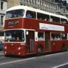
inspector Posted January 3, 2021 Share Posted January 3, 2021 13 minutes ago, Maroon Sailor said: Slateford Road again. The Maltings opposite Moat Terrace/Street. Flats now l think Quote Link to comment Share on other sites More sharing options...
Maroon Sailor Posted January 3, 2021 Author Share Posted January 3, 2021 2 minutes ago, inspector said: Slateford Road again. The Maltings opposite Moat Terrace/Street. Flats now l think What was that building on the left ? Quote Link to comment Share on other sites More sharing options...
Maroon Sailor Posted January 3, 2021 Author Share Posted January 3, 2021 Juniper Green Quote Link to comment Share on other sites More sharing options...
inspector Posted January 3, 2021 Share Posted January 3, 2021 1 minute ago, Maroon Sailor said: What was that building on the left ? Sorry can't remember now. From the looks of it, it could be a garage/ tyre depot Quote Link to comment Share on other sites More sharing options...
Maroon Sailor Posted January 3, 2021 Author Share Posted January 3, 2021 Quote Link to comment Share on other sites More sharing options...
Maroon Sailor Posted January 3, 2021 Author Share Posted January 3, 2021 Quote Link to comment Share on other sites More sharing options...
Governor Tarkin Posted January 3, 2021 Share Posted January 3, 2021 1 minute ago, Maroon Sailor said: Colinton Mains Drive. 1 minute ago, Maroon Sailor said: Oxgangs by the Broadway and the View. Quote Link to comment Share on other sites More sharing options...
The Real Maroonblood Posted January 3, 2021 Share Posted January 3, 2021 12 minutes ago, Maroon Sailor said: Juniper Green I’m sure that’s now Molly’s Cafe. Quote Link to comment Share on other sites More sharing options...
Maroon Sailor Posted January 3, 2021 Author Share Posted January 3, 2021 1 minute ago, Governor Tarkin said: Colinton Mains Drive What was going on here ? Quote Link to comment Share on other sites More sharing options...
Governor Tarkin Posted January 3, 2021 Share Posted January 3, 2021 (edited) 6 minutes ago, Maroon Sailor said: What was going on here ? Building the row of shops. That's me on the back of Ferry's pickup. Edited January 3, 2021 by Governor Tarkin Quote Link to comment Share on other sites More sharing options...
Maroon Sailor Posted January 3, 2021 Author Share Posted January 3, 2021 Woodhall Drive Quote Link to comment Share on other sites More sharing options...
¼½¾ Posted January 3, 2021 Share Posted January 3, 2021 Napier Road. Apparently built with stone from every quarry in Scotland, and some further afield. Demolished in the 60s to build this... Quote Link to comment Share on other sites More sharing options...
Maroon Sailor Posted January 3, 2021 Author Share Posted January 3, 2021 Quote Link to comment Share on other sites More sharing options...
Maroon Sailor Posted January 3, 2021 Author Share Posted January 3, 2021 Quote Link to comment Share on other sites More sharing options...
Maroon Sailor Posted January 3, 2021 Author Share Posted January 3, 2021 28 minutes ago, The Real Maroonblood said: I’m sure that’s now Molly’s Cafe. I thought it was The Candy Box (now a chemist) but that slope tells me it's not. If I could make out the number of the shop it would help ! Quote Link to comment Share on other sites More sharing options...
NANOJAMBO Posted January 3, 2021 Share Posted January 3, 2021 1 hour ago, Maroon Sailor said: Somewhere near the top of Drum Brae - near the bus terminus ? Quote Link to comment Share on other sites More sharing options...
FORTHCLYDE Posted January 3, 2021 Share Posted January 3, 2021 Did anyone ever discover where this was? I spent hours trying to work it out when it was first published. Quote Link to comment Share on other sites More sharing options...
inspector Posted January 3, 2021 Share Posted January 3, 2021 57 minutes ago, Maroon Sailor said: I thought it was The Candy Box (now a chemist) but that slope tells me it's not. If I could make out the number of the shop it would help ! The Candy Box was further down the road. Think it's a chemist now Quote Link to comment Share on other sites More sharing options...
Maroon Sailor Posted January 3, 2021 Author Share Posted January 3, 2021 10 minutes ago, FORTHCLYDE said: Did anyone ever discover where this was? I spent hours trying to work it out when it was first published. Was that not Carrick Knowe / Broomhall area ? Quote Link to comment Share on other sites More sharing options...
Maroon Sailor Posted January 3, 2021 Author Share Posted January 3, 2021 18 minutes ago, NANOJAMBO said: Somewhere near the top of Drum Brae - near the bus terminus ? Oxgangs Governor Tarkin even knew the street in his reply above Quote Link to comment Share on other sites More sharing options...
Maroon Sailor Posted January 3, 2021 Author Share Posted January 3, 2021 Quote Link to comment Share on other sites More sharing options...
Maroon Sailor Posted January 3, 2021 Author Share Posted January 3, 2021 Quote Link to comment Share on other sites More sharing options...
Maroon Sailor Posted January 3, 2021 Author Share Posted January 3, 2021 Quote Link to comment Share on other sites More sharing options...
argyjambo Posted January 3, 2021 Share Posted January 3, 2021 3 hours ago, Maroon Sailor said: Easter Road, just before the junction with Albion Road? Quote Link to comment Share on other sites More sharing options...
Maroon Sailor Posted January 3, 2021 Author Share Posted January 3, 2021 1 minute ago, argyjambo said: Easter Road, just before the junction with Albion Road? I had this down as Slateford Road looking west Quote Link to comment Share on other sites More sharing options...
Tazio Posted January 3, 2021 Share Posted January 3, 2021 28 minutes ago, argyjambo said: Easter Road, just before the junction with Albion Road? That’s what I instinctively thought but it isn’t. The church that looks like that on Easter Road is the episcopal church at Sunnyside so a whole block south of the Albion Road bridge. Quote Link to comment Share on other sites More sharing options...
Governor Tarkin Posted January 3, 2021 Share Posted January 3, 2021 28 minutes ago, Maroon Sailor said: I had this down as Slateford Road looking west You would be correct. Quote Link to comment Share on other sites More sharing options...
Maroon Sailor Posted January 3, 2021 Author Share Posted January 3, 2021 Quote Link to comment Share on other sites More sharing options...
Maroon Sailor Posted January 3, 2021 Author Share Posted January 3, 2021 Quote Link to comment Share on other sites More sharing options...
Maroon Sailor Posted January 3, 2021 Author Share Posted January 3, 2021 Quote Link to comment Share on other sites More sharing options...
Jambo314 Posted January 3, 2021 Share Posted January 3, 2021 13 minutes ago, Maroon Sailor said: Newhaven Rd, Stanley Rd to the left and Hawthornvale to the right? Quote Link to comment Share on other sites More sharing options...
Les Izemore Posted January 3, 2021 Share Posted January 3, 2021 15 minutes ago, Maroon Sailor said: Is this Newhaven Road and the car turning right from Stanley Road? Quote Link to comment Share on other sites More sharing options...
The Real Maroonblood Posted January 3, 2021 Share Posted January 3, 2021 2 hours ago, inspector said: The Candy Box was further down the road. Think it's a chemist now It’s Molly’s Cafe. Quote Link to comment Share on other sites More sharing options...
¼½¾ Posted January 3, 2021 Share Posted January 3, 2021 9 minutes ago, Maroon Sailor said: Royal Park Terrace. Quote Link to comment Share on other sites More sharing options...
Jambo314 Posted January 3, 2021 Share Posted January 3, 2021 13 minutes ago, Maroon Sailor said: Muirhouse Park? Quote Link to comment Share on other sites More sharing options...
Carl Fredrickson Posted January 3, 2021 Share Posted January 3, 2021 1 hour ago, Maroon Sailor said: My sister lived in Muirhouse in the late 70s/early80s and I dreaded visiting her. We grew up out in the sticks and visiting her with no garden, everywhere was either concrete or grass covered in dog crap and/or broken glass was an eye opener for me. This image is very similar to what I remember of those days. A trip to the local shops was "interesting" and passing the Gunner with some of its customers hanging around outside was frightening (I was still at primary school). Quote Link to comment Share on other sites More sharing options...
Maroon Sailor Posted January 3, 2021 Author Share Posted January 3, 2021 Quote Link to comment Share on other sites More sharing options...
3fingersreid Posted January 3, 2021 Share Posted January 3, 2021 5 hours ago, Maroon Sailor said: Slateford road , church where I was christened , now flats , chimney on the left was where the goods yard to Waddies the Printers was ,the print works long gone but the chimney is still there, many happy days there. The bus in the foreground, to its left was where Johnny Hamilton’s shop was . Can’t see it from the picture but Legitts garage would’ve been on the right hand side Quote Link to comment Share on other sites More sharing options...
Maroon Sailor Posted January 3, 2021 Author Share Posted January 3, 2021 Quote Link to comment Share on other sites More sharing options...
Maroon Sailor Posted January 3, 2021 Author Share Posted January 3, 2021 Quote Link to comment Share on other sites More sharing options...
Maroon Sailor Posted January 3, 2021 Author Share Posted January 3, 2021 Quote Link to comment Share on other sites More sharing options...
Maroon Sailor Posted January 3, 2021 Author Share Posted January 3, 2021 Quote Link to comment Share on other sites More sharing options...

Recommended Posts
Join the conversation
You can post now and register later. If you have an account, sign in now to post with your account.