Maroon Sailor Posted February 4, 2019 Author Share Posted February 4, 2019 Quote Link to comment Share on other sites More sharing options...
Maroon Sailor Posted February 4, 2019 Author Share Posted February 4, 2019 Quote Link to comment Share on other sites More sharing options...
Maroon Sailor Posted February 4, 2019 Author Share Posted February 4, 2019 Quote Link to comment Share on other sites More sharing options...
Maroon Sailor Posted February 4, 2019 Author Share Posted February 4, 2019 Quote Link to comment Share on other sites More sharing options...
Maroon Sailor Posted February 4, 2019 Author Share Posted February 4, 2019 Quote Link to comment Share on other sites More sharing options...
Maroon Sailor Posted February 4, 2019 Author Share Posted February 4, 2019 Quote Link to comment Share on other sites More sharing options...
Maroon Sailor Posted February 4, 2019 Author Share Posted February 4, 2019 Quote Link to comment Share on other sites More sharing options...
Shanks said no Posted February 4, 2019 Share Posted February 4, 2019 1 hour ago, Maroon Sailor said: The sad thing about this picture is that I think I remember it happening Quote Link to comment Share on other sites More sharing options...
Maroon Sailor Posted February 4, 2019 Author Share Posted February 4, 2019 Quote Link to comment Share on other sites More sharing options...
Maroon Sailor Posted February 4, 2019 Author Share Posted February 4, 2019 Quote Link to comment Share on other sites More sharing options...
Maroon Sailor Posted February 4, 2019 Author Share Posted February 4, 2019 Quote Link to comment Share on other sites More sharing options...
Maroon Sailor Posted February 4, 2019 Author Share Posted February 4, 2019 Quote Link to comment Share on other sites More sharing options...
Maroon Sailor Posted February 4, 2019 Author Share Posted February 4, 2019 Quote Link to comment Share on other sites More sharing options...
Maroon Sailor Posted February 4, 2019 Author Share Posted February 4, 2019 Quote Link to comment Share on other sites More sharing options...
been here before Posted February 4, 2019 Share Posted February 4, 2019 1 hour ago, The Frenchman Returns said: The sad thing about this picture is that I think I remember it happening If that the railway bridge at Meggetgate then it still floods every year. Quote Link to comment Share on other sites More sharing options...
Les Izemore Posted February 4, 2019 Share Posted February 4, 2019 57 minutes ago, Maroon Sailor said: The ground floor far end of that long stone built building is my old local, Gladstones in Great Junction Street. Quote Link to comment Share on other sites More sharing options...
Morgan Posted February 4, 2019 Share Posted February 4, 2019 5 hours ago, Maroon Sailor said: This one taken from Picardy Place? Quote Link to comment Share on other sites More sharing options...
Morgan Posted February 4, 2019 Share Posted February 4, 2019 1 hour ago, Maroon Sailor said: Between Holy Corner and Churchill, looking down into Morningside? Quote Link to comment Share on other sites More sharing options...
Morgan Posted February 4, 2019 Share Posted February 4, 2019 1 hour ago, Maroon Sailor said: Old Royal Infirmary (Accident and Emergency)? Quote Link to comment Share on other sites More sharing options...
Morgan Posted February 4, 2019 Share Posted February 4, 2019 1 hour ago, Maroon Sailor said: Corn Exchage? Quote Link to comment Share on other sites More sharing options...
Morgan Posted February 4, 2019 Share Posted February 4, 2019 5 hours ago, Maroon Sailor said: Top of Lothian Road heading towards Tollcross, opposite Woolies? Quote Link to comment Share on other sites More sharing options...
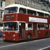
The Real Maroonblood Posted February 4, 2019 Share Posted February 4, 2019 5 hours ago, Maroon Sailor said: Is that at Slateford? Quote Link to comment Share on other sites More sharing options...
¼½¾ Posted February 4, 2019 Share Posted February 4, 2019 2 hours ago, Maroon Sailor said: 46 minutes ago, Morgan said: Corn Exchage? I think the wee round sign over the door says 'Police'. Quote Link to comment Share on other sites More sharing options...
Sharpie Posted February 4, 2019 Share Posted February 4, 2019 50 minutes ago, Morgan said: Old Royal Infirmary (Accident and Emergency)? Middle Meadow Walk entrance.Police box at the top of the Walk real close to this door. Spent a bit of time in there, day shift and afternoon shift chec king for other policemen the disposition of the person they were dealing with. Night shift removing drunks who were in to see friends who had been involved in accidents. The most important time was spent chatting up nurses as a young single policeman. The S.O.P.D as it wass known in these long gone dark ages. Quote Link to comment Share on other sites More sharing options...
Sharpie Posted February 4, 2019 Share Posted February 4, 2019 56 minutes ago, Morgan said: Top of Lothian Road heading towards Tollcross, opposite Woolies? Newington Road just after East Preston Street Quote Link to comment Share on other sites More sharing options...
Morgan Posted February 4, 2019 Share Posted February 4, 2019 24 minutes ago, Lemongrab said: I think the wee round sign over the door says 'Police'. Not that I’m one to pass the buck but, it was my wife’s guess, and I let her post it. In fact, all five posts were from her. Quote Link to comment Share on other sites More sharing options...
Morgan Posted February 4, 2019 Share Posted February 4, 2019 15 minutes ago, bobsharp said: Newington Road just after East Preston Street 100% sure Bob? We still think it looks like Lothian Road. Quote Link to comment Share on other sites More sharing options...
ArcticJambo Posted February 4, 2019 Share Posted February 4, 2019 1 hour ago, Morgan said: Corn Exchage? It's been posted before and I believe identified as Gayfield Square. Quote Link to comment Share on other sites More sharing options...
Morgan Posted February 4, 2019 Share Posted February 4, 2019 Just now, ArcticJambo said: It's been posted before and I believe identified as Gayfield Square. Hence the ‘Police’ sign! Can’t believe I never noticed that! Quote Link to comment Share on other sites More sharing options...
Sharpie Posted February 4, 2019 Share Posted February 4, 2019 1 minute ago, Morgan said: 100% sure Bob? We still think it looks like Lothian Road. Pretty sure, and I am sure the opening down on the left is East Newington Place with the bank on the corner, only spent the first twenty years of my life there but that was a long time ago so mistakes can happen, but I don't think so.? Quote Link to comment Share on other sites More sharing options...
Morgan Posted February 4, 2019 Share Posted February 4, 2019 1 minute ago, bobsharp said: Pretty sure, and I am sure the opening down on the left is East Newington Place with the bank on the corner, only spent the first twenty years of my life there but that was a long time ago so mistakes can happen, but I don't think so.? Fair enough Bob. ? Quote Link to comment Share on other sites More sharing options...
ArcticJambo Posted February 4, 2019 Share Posted February 4, 2019 7 hours ago, Maroon Sailor said: https://goo.gl/maps/SjNAsjUY7x72 Quote Link to comment Share on other sites More sharing options...
luckyBatistuta Posted February 4, 2019 Share Posted February 4, 2019 1 hour ago, Morgan said: Between Holy Corner and Churchill, looking down into Morningside? This doesn’t look right to me my old mucker Quote Link to comment Share on other sites More sharing options...
Morgan Posted February 4, 2019 Share Posted February 4, 2019 2 minutes ago, luckyBatistuta said: This doesn’t look right to me my old mucker I agree. As posted above, it was my wife who posted these. That’s the last time that happens! Quote Link to comment Share on other sites More sharing options...
ArcticJambo Posted February 4, 2019 Share Posted February 4, 2019 7 minutes ago, luckyBatistuta said: This doesn’t look right to me my old mucker I thought it might be Rossie place looking towards Easter Road, with colony terraced houses on left running up to Abbeyhill. Seems to be something like that with those gable ends perpendicular to the street. Quote Link to comment Share on other sites More sharing options...
¼½¾ Posted February 4, 2019 Share Posted February 4, 2019 14 minutes ago, ArcticJambo said: I thought it might be Rossie place looking towards Easter Road, with colony terraced houses on left running up to Abbeyhill. Seems to be something like that with those gable ends perpendicular to the street. The Pinterest site has this labelled as Rossie Place. Quote Link to comment Share on other sites More sharing options...
ArcticJambo Posted February 4, 2019 Share Posted February 4, 2019 (edited) 11 minutes ago, Lemongrab said: The Pinterest site has this labelled as Rossie Place. That's an educated guess, from countless bored bus trips between Portobello and the town over the years. Staring out the top deck looking down Carlyle Place whilst sat at the Abbeyhill bus-stop. Edited February 4, 2019 by ArcticJambo Quote Link to comment Share on other sites More sharing options...
luckyBatistuta Posted February 4, 2019 Share Posted February 4, 2019 28 minutes ago, ArcticJambo said: I thought it might be Rossie place looking towards Easter Road, with colony terraced houses on left running up to Abbeyhill. Seems to be something like that with those gable ends perpendicular to the street. That was my first thought, but dismissed after checking google earth. Doesn’t look right either to me. Quote Link to comment Share on other sites More sharing options...
Maroon Sailor Posted February 4, 2019 Author Share Posted February 4, 2019 2 hours ago, The Real Maroonblood said: Is that at Slateford? It is I also remember a bus getting stuck under that bridge when it's roof hit in to it Quote Link to comment Share on other sites More sharing options...
NANOJAMBO Posted February 4, 2019 Share Posted February 4, 2019 5 hours ago, Maroon Sailor said: Leith Walk, near MacDonald Rd ? Quote Link to comment Share on other sites More sharing options...
Maroon Sailor Posted February 4, 2019 Author Share Posted February 4, 2019 2 minutes ago, NANOJAMBO said: Leith Walk, near MacDonald Rd ? Yeah - kind of threw me as I can't remember the 12 going to Hay Drive via Leith Walk Quote Link to comment Share on other sites More sharing options...
Maroon Sailor Posted February 4, 2019 Author Share Posted February 4, 2019 1 hour ago, ArcticJambo said: It's been posted before and I believe identified as Gayfield Square. I might have posted it before. Something about a car like that being parked outside a Police Station Quote Link to comment Share on other sites More sharing options...
Montgomery Brewster Posted February 4, 2019 Share Posted February 4, 2019 1 hour ago, Morgan said: 100% sure Bob? We still think it looks like Lothian Road. Yes that’s the southside . 100% Quote Link to comment Share on other sites More sharing options...
Morgan Posted February 4, 2019 Share Posted February 4, 2019 2 minutes ago, Montgomery Brewster said: Yes that’s the southside . 100% Ta. Quote Link to comment Share on other sites More sharing options...
Montgomery Brewster Posted February 4, 2019 Share Posted February 4, 2019 3 minutes ago, Morgan said: Ta. I know the bit of lothian road you mean and they are very similar . The old bank on the corner was the clincher though. Quote Link to comment Share on other sites More sharing options...
Morgan Posted February 4, 2019 Share Posted February 4, 2019 5 minutes ago, Montgomery Brewster said: I know the bit of lothian road you mean and they are very similar . The old bank on the corner was the clincher though. Now that I look closer at the bank, it just seems to 'stick out' more than the TSB on the corner of Lothian Road does. I had initially thought that the shop that looks like it is called 'Coopers' was where the Burnt Post used to be, or maybe Ali's Cave, Quote Link to comment Share on other sites More sharing options...
The Real Maroonblood Posted February 4, 2019 Share Posted February 4, 2019 31 minutes ago, Maroon Sailor said: It is I also remember a bus getting stuck under that bridge when it's roof hit in to it Thanks for that. Quote Link to comment Share on other sites More sharing options...
Maroon Sailor Posted February 4, 2019 Author Share Posted February 4, 2019 3 hours ago, Morgan said: This one taken from Picardy Place? Making the roundabout Quote Link to comment Share on other sites More sharing options...
EIEIO Posted February 4, 2019 Share Posted February 4, 2019 Kind of on topic there's a great wee exhibition currently at the city art centre in market street. Photographs of Edinburgh people and streets in the mid 1960s taken by a guy from Yorkshire who was a medical student here, he's now 80 and in a wheelchair having had a stroke about 20 years ago. Robert Blomfield is the guys name about 60 photos and a short video , it's on the 2nd floor. Free entry recommend it. Quote Link to comment Share on other sites More sharing options...
Carl Fredrickson Posted February 4, 2019 Share Posted February 4, 2019 Thanks for bringing this thread back. I have spent a while today catching up with it and as well as seeing the great old images, I also enjoy the posts by folk that can remember things as they were (makes me feel young!) Keep up the good work chaps. Quote Link to comment Share on other sites More sharing options...


Recommended Posts
Join the conversation
You can post now and register later. If you have an account, sign in now to post with your account.